A Visit to Organ Pipe Cactus National Monument – A Biosphere Reserve

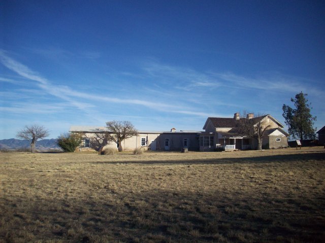
Organ Pipe Cactus National Monument is located in southwestern Arizona in the heart of the Sonoran Desert. The national monument is bisected by the southernmost portion of State Route 85 which ends at the U.S.-Mexico border; in fact, the 31-mile southern boundary of the national monument is the border. The Kris Eggle Visitor Center is located approximately 25 miles south of Why, Arizona and approximately 36 miles south of Ajo, Arizona on Highway 85.

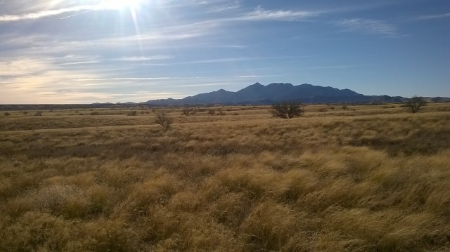
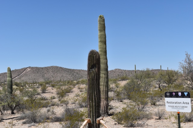
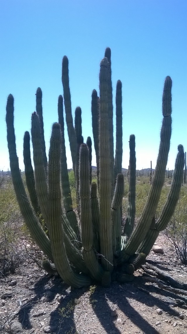
There are many reasons to visit Organ Pipe Cactus National Monument some of which include the opportunity to see an organ pipe cactus since the monument was established in 1937 to protect the species’ northernmost habitat in the United States. Organ pipe cacti are more common in southern regions across the border where they are less prone to frost. The national monument protects 516 square miles of Sonoran Desert habitat – over 95% is designated as wilderness.

A wilderness designation refers to the highest level of protection federal lands are eligible for, and only Congress can designate wilderness areas within existing public lands. Organ Pipe Cactus National Monument is administered by the National Park Service. The National Park Service is celebrating its Centennial in 2016, so go ‘Find Your Park’ (#FINDYOURPARK) for more information about Centennial celebrations. Organ Pipe Cactus National Monument is also a Biosphere Reserve. Biosphere Reserves are non-regulatory protected areas that differ from other national designations and are part of a world network of biosphere reserves under the umbrella of UNESCO’s Man and the Biosphere Program.

Organ Pipe Cactus National Monument is home to endangered species such as the Sonoran pronghorn and the Quitobaquito pupfish year round and seasonally to the Lesser long-nosed bat which migrates to the Sonoran desert in the spring from central Mexico to give birth to their young and to feed on the nectar and fruit of the organ pipe cactus and saguaros. Visitors can enjoy the abundant wildlife, the unpolluted night sky, drive on scenic roads, hike desert trails, camp, or just stop by the visitor’s center for an introduction to the monument.

Of course as with most things in life, the monument’s existence has not been a fairytale, being on the US-Mexico border has led to unique circumstances that affect the entire border region not just the monument. The US-Mexico border region is an area where the supply and demand of illegal drugs and cheap labor is the most evident, and ever since an intense crack-down on smuggling at border cities and towns occurred in the 1990’s a lot of the illegal activities shifted to unpopulated, rugged country such as the national monument.

In 2002, Kris Eggle, a law enforcement park ranger was killed on duty by a drug trafficker. After the park ranger’s death, a vehicle barrier was constructed along the border and most of the land was closed to the public until 2014 when public access to the entire national monument was reinstated.

One of the areas previously off-limits to the public was Quitobaquito Pond due to its proximity to the border – only a few meters from the fence. Quitobaquito is a special place not only for its ecological significance but because of its cultural significance as well. Artifacts dating back 16,000 years have been found in the area. Quitobaquito is associated with a prehistoric trade route known as the Old Salt Trail in which the ancient inhabitants of the land traded salt, obsidian, and seashells. Quitobaquito Springs later became the home of the Hia C-ed O’odham and the Tohono O’odham. Currently, the eastern boundary of Organ Pipe Cactus National Monument coincides with the southwestern boundary of the Tohono O’odham Nation.

ORPI 020
Quitobaquito
ORPI 035
Quitobaquito pond is fed by natural springs.

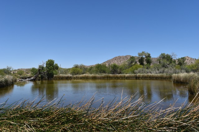
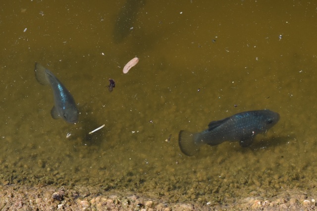
The ecological significance of Quitobaquito cannot be overstated. Quitobaquito is the only natural place where the endangered Quitobaquito pupfish (Cyprinodon eremus) can be found in the U.S., and it is the only place in the U.S. where the Sonoyta mud turtle and the tiny Quitobaquito springsnail can be found. Quitobaquito pupfish can also be found in a handful of artificial refuge ponds in Arizona and Sonora.

2016 Edited close ups 005
Quitobaquito/Rio Sonoyta Pupfish ~ picture taken at refuge pond in Mexico.

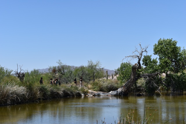
I had visited Organ Pipe Cactus National Monument before, but it wasn’t until my most recent visit in the spring that I got to see Quitobaquito and many other areas that I probably would not have visited had it not been for the fortunate opportunity I had to help out on a wildlife camera deployment project led by the Sonoran Desert Monitoring Network. Deploying wildlife cameras means hiking off-trail to remote areas that are not generally frequented by the general public, so there is a sense of being out in the ‘wilderness’; a conflicted wilderness, but a wilderness nonetheless.

The Border Patrol’s presence has increased over the years and more agents with more vehicles led to a lot of illegal roads within the wilderness area, before the installation of the vehicle barrier, drug traffickers also created illegal roads. Off-road driving inevitably leads to habitat fragmentation; fortunately, the Department of Homeland Security funded a road restoration project recently at Organ Pipe Cactus National Monument and at adjacent Cabeza Prieta National Wildlife Refuge; thus far, miles and miles of roads have been restored.

ORPI 010
Restoration area near border fence.

From a bird’s eye view the landscape looks unspoiled, but in certain ‘high traffic’ areas you do encounter trash left behind by border crossers and ATV tracks left behind by law enforcement. A common item that litters the landscape and can be found anywhere along the border not just at the national monument is the iconic black water jug – a plastic item – that represents the difference between life and death in a hostile environment. I want to clarify that even though we hiked many miles the area we covered represents only a tiny fraction of the land and we also encountered many places where the landscape appeared pristine.

Non-profit organizations such as Human Borders services and maintains emergency water stations throughout the Sonoran desert border region in an effort to prevent migrant deaths – according to some reports since 2001 over 2,000 people have died attempting to cross the Arizona-Mexico border as a result of dehydration, sunstroke, and exposure. The Border Patrol also rescues people throughout the region. Emergency assistance towers next to roads where people can pick up the phone and request assistance can be seen from a great distance.

A few days are not enough to explore the many corners of the monument, and there are still many corners I want to explore especially in the mountains. I encourage people to visit Organ Pipe Cactus National Monument and other natural protected areas along the border so they can see for themselves what it is like and to learn about the many wildlife and cultural treasures along the border, but remember if you go, always go prepared with more water than you think you need and always be cautious of your surroundings. Organ Pipe Cactus National Monument is a truly special place, so if you’re ever in the area don’t hesitate to visit – it is worth it.

WP_20160424_13_40_25_Pro

For more information about Organ Pipe Cactus National Monument go to:

http://www.nps.gov/orpi/index.htm


Following History’s Footsteps in a Riparian Area

The 1200 mile long Juan Bautista de Anza National Historic Trail commemorates the 1775-76 expedition led by Juan Bautista de Anza to establish a mission and presidio or garrison – in what is now San Francisco, California – during Spanish colonial rule. Juan Bautista de Anza led more than 240 men, women, and children along with their belongings, horses, pack animals, and heads of cattle from San Miguel de Horcasitas Presidio in what is now the state of Sonora, Mexico to what is now the San Francisco Bay Area. The journey took six months to complete. The Juan Bautista de Anza National Historic Trail is managed by the National Park Service and in the U.S. the trail starts in modern day Nogales, Arizona and ends in modern day San Francisco, California.  Recently, I followed a small section of the historic trail that parallels and crosses the Santa Cruz River in Arizona from Tumacacori to Tubac.

DSC_0088

Juan Bautista de Anza was born in Fronteras Presidio, Sonora in 1735 or 1736; de Anza became Captain of the Presidio of Tubac in 1774; and, that same year he travelled from Tubac to Mission San Gabriel and Monterrey Presidio in California to establish a direct land route to Alta California. Juan made a second journey to Alta California following the same route in 1775-76. The main reason why Spanish authorities wanted to establish a new settlement in San Francisco was to halt the advancement of Russian settlements in Alta California – the southernmost Russian settlement was Fort Ross.

After he returned from his second journey to Alta California, Juan de Anza was named Governor of New Mexico. He died in 1788 in the town of Arizpe in what is now the Mexican state of Sonora. Even though the trail is named after Juan Bautista de Anza, there is no doubt in my mind that his success in finding a safe land route could not have been possible without the help of Native Americans as guides, interpreters, and their keen knowledge of the land and its resources.

The Anza Trail was designated as a National Historic Trail in 1990. It traverses five counties in Arizona and 14 counties in California. I only walked 3.5 miles of the trail in Santa Cruz County; nonetheless, I think this small section is a great place to get an idea of what the expedition members encountered on the road. The Santa Cruz River offered the expedition a reliable source of water and relatively easy terrain on which to travel.

The Santa Cruz River is the only river in the United States that crosses an international border twice; it originates in the Canelo Hills of southeastern Arizona then flows south to Mexico, makes a U-turn after a few miles, and returns to Arizona near Nogales. Currently, the Santa Cruz River is dry most of the year except during the monsoon season when it is common to see surface water on the river bed. The section of the river between Tumacacori and Tubac is effluent dependent. The treated wastewater comes from the Nogales International Wastewater Treatment Plant – I mention more details about the wastewater treatment plant and Tumacacori Mission in a previous blog post published in April of 2014.

Blog 034
Tumacacori National Historical Park

Despite the source of the surface water I find this section of the Anza Trail appealing since the cottonwood-willow gallery and the mesquite bosque provide a serene environment in which to contemplate the history of the region and enjoy the wildlife that depends on the riparian area. Riparian areas are extremely important for local and migrating wildlife species such as birds; riparian areas are also threatened ecosystems. In Arizona, it is estimated that less than 10% of the state’s original riparian habitat remains intact. According to the Arizona Riparian Council, approximately 60-75% of the state’s resident wildlife species depend on riparian areas to sustain their populations; yet, riparian areas occupy less than 0.5% of Arizona’s total land area.

The Santa Cruz River riparian area is recognized as an Important Bird and Biodiversity Area. A testament to the importance of this area for the biological diversity of the region is the recent rediscovery of the Gila topminnow. The Gila topminnow is 1-2 inch Endangered native fish. This native fish was last seen in the Upper Santa Cruz River in 2005, and after a 10 year absence the native fish species was reported during the most recent fish survey in 2015. The re-appearance of Gila topminnow in the river is possibly due to incoming flash floods from Sonoita Creek – a tributary of the Santa Cruz River where the endangered fish can still be found.

I personally did not see any fish this last time I hiked the trail, but I do remember seeing fish in the early 2000’s. The Anza trail between Tumacacori and Tubac crosses the river a couple of times, the crossing is made easier by pedestrian foot bridges provided by the Arizona Anza Trail Coalition. I hiked the trail in mid-January and possibly due to recent winter rains or maybe as a result of the last monsoon season – a portion of the trail before Clark Crossing – and possibly part of the trail located on private land all but disappeared. On that particular section of the river, a good amount of wooden debris had accumulated as well as a good amount of trash. After what felt like a leisurely walk by the river and across foot bridges the time had come to get wet and muddy feet – I enjoyed it since it provided me with an opportunity to wonder what the Anza expedition had encountered along this stretch of the river. The section of the trail from Clark Crossing to Tubac is well maintained and it’s an easy walk.

Tubac was Camp #14 of Anza’s expedition and it’s where Anza gathered all of the future settlers, made final preparations, and set out in October of 1775 as a complete expedition. Tubac had been settled by Pima Native Americans for centuries prior to the arrival of Spanish colonists. The Presidio of Tubac was founded in 1752 in response to an uprising of the local Pimas. The old presidio walls are mostly gone but portions of it as well as the presidio’s foundation can still be seen at Tubac Presidio State Historic Park – which happens to be Arizona’s 1st state park.

The town of Tubac has experienced many changes and rebirths throughout the centuries most recently as a hub for artisans and tourists in Southern Arizona; yet old Tubac where Tubac Presidio State Historic Park is located retains its small southwestern town charm. A visit to the State Historic Park and its surroundings is a visual treat since one can get a sense of the different cultural influences in the region ranging from Native American, Spanish, Mexican, and finally Anglo-European.

Tumacacori National Historical Park, the Anza Trail, the Santa Cruz River, and Tubac Presidio State Park are all easily accessible via Interstate 19 which connects Nogales, Arizona on the border with Mexico to Tucson, Arizona only about 60 miles away making it one of the shortest Interstates in the U.S and also a unique one since distances are given in meters and kilometers unlike other Interstates, so the next time you travel on I-19 or if you are ever in this area remember to look East and think about all the history and biodiversity present along this corridor.

Beautiful Landscape, History, and Wildlife at Las Cienegas National Conservation Area

Las Cienegas National Conservation Area is located 45 miles southeast of Tucson, Arizona; about 40 miles north of the US-Mexico border; and, about 10 miles north of Sonoita, Arizona on Arizona Highway 83. Las Cienegas National Conservation Area consists of 45,000 acres of public land managed by the Department of Interior’s Bureau of Land Management (BLM). The vegetative communities at Las Cienegas are typical of what was common centuries ago and is now rare such as cottonwood-willow galleries, semi-desert grassland, sacaton grasslands, cienegas, and mesquite bosques.  Las Cienegas is also an example of the gradual transformation of the land over the course of the last 150 years or so from native grasslands into mesquite woodlands as a result of changes in the natural fire regime and cattle grazing.

Las Cienegas 001

One of the most visible negative consequences of land degradation is loss of habitat for grassland depended species such as pronghorn and prairie dogs just to name a few, but there are other equally important yet inconspicuous consequences such as watershed functions. The BLM is currently implementing a grassland restoration project on 20,000 acres of degraded habitat at Las Cienegas, whereby mechanical thinning of mesquite woodlands, they hope to reestablish a healthy grassland ecosystem for the benefit of wildlife and all who wish to enjoy it.

WP_20151128_15_06_06_Pro
Las Cienegas National Conservation Area

Las Cienegas is not only home to 60 species of mammals, 230 species of birds, 43 species of reptiles and amphibians, and 3 species of native fish including some that are listed as threatened and endangered such as the Gila topminnow and Southwestern willow flycatcher, but is also home to Empire Ranch. Empire Ranch was founded in 1876 with the purchase of a 160-acre ranch originally established in the 1860’s as a homestead ranch. Over the years the ranch house as well as the ranch itself expanded and changed ownership a few times until 1988 when the BLM acquired the lands through a public-private land swap and created the Empire-Cienega Resource Conservation Area. In 2000, the U.S. Congress established the 45,000 acre Las Cienegas National Conservation Area.

Las Cienegas 058
Empire Ranch House

The lands occupied by Empire Ranch and Las Cienegas have a rich and complex ownership history from the original inhabitants and owners – Native Americans – to the beginnings of Spanish physical presence in 1691 to Mexican ownership as a result of Spanish independence in 1821 to the sale of the lands encompassing modern day southern Arizona and southwestern New Mexico in 1854 in what is known as the Gadsden Purchase.

In 1997, the non-profit Empire Ranch Foundation was founded with the aim of protecting and restoring Empire Ranch’s historical buildings. The ranch house – a 22-room building which dates to 1870 – was listed on the National Register of Historic Places in 1975. Thanks to the Empire Ranch Foundation and its supporters the Empire Ranch House has been preserved and can be enjoyed free of charge on self-guided tours year-long. Each room retains its charm and one can get a sense of what life was like in the rural southwest by experiencing the atmosphere recreated in each room and/or reading about it on the interpretative signage throughout the building.

Near the ranch house one can also enjoy a short but pleasant half-mile walk on the Heritage Discovery Trail which meanders next to a cottonwood grove. There are many outdoor activities that people can enjoy at Las Cienegas, but a unique watchable wildlife opportunity in Arizona is only available at Las Cienegas – watching black-tailed prairie dogs. Remember to always be respectful of all wildlife – for wildlife watching tips visit Arizona Watchable Wildlife Tourism Association at http://www.azwatchablewildlife.org/index.php/wildlife-resources/viewing-tips.

Black-tailed prairie dogs are one of five species of prairie dogs and the species with formerly the most expansive range – from southern Canada to northern Mexico. Unfortunately, over the past 150 years their range has been reduced to less than 2% and accordingly their numbers have been greatly reduced. In Arizona, black-tailed prairie dogs were exterminated in 1960. Fortunately, wildlife agencies and multiple partners have worked together to re-establish the species not just in Arizona but across their historic range. In Arizona, black-tailed prairie dogs were first re-introduced in 2008 and since then three colonies have been successfully established at Las Cienegas. Prairie dogs are a grassland dependent keystone species; that is they have a big impact on their ecosystem, and other species depend on them for food and shelter. The reintroduction of black-tailed prairie dogs at Las Cienegas National Conservation Area is a positive sign on the road to restoring a diverse and healthy ecosystem.


If you’d like to learn more visit the following websites:

Las Cienegas National Conservation Area – BLM Website

http://www.blm.gov/az/st/en/prog/blm_special_areas/ncarea/lascienegas.html

Empire Ranch Foundation

https://www.empireranchfoundation.org/

Black-tailed Prairie Dog Reintroduction – Arizona Game and Fish Department Website

http://www.gf.state.az.us/w_c/nongameandendangeredwildlifeprogram/Black-tailedPrairieDog.shtml