Following History’s Footsteps in a Riparian Area

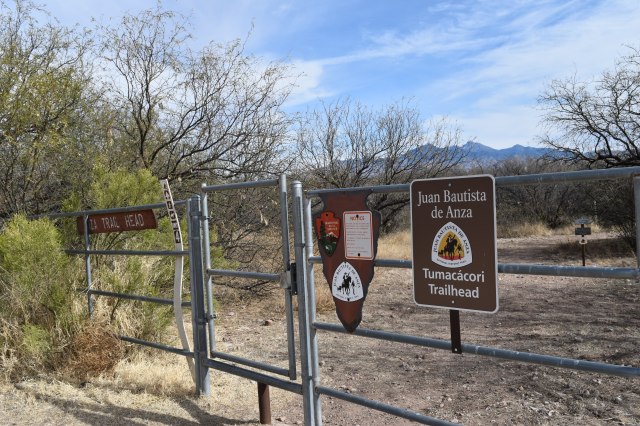
The 1200 mile long Juan Bautista de Anza National Historic Trail commemorates the 1775-76 expedition led by Juan Bautista de Anza to establish a mission and presidio or garrison – in what is now San Francisco, California – during Spanish colonial rule. Juan Bautista de Anza led more than 240 men, women, and children along with their belongings, horses, pack animals, and heads of cattle from San Miguel de Horcasitas Presidio in what is now the state of Sonora, Mexico to what is now the San Francisco Bay Area. The journey took six months to complete. The Juan Bautista de Anza National Historic Trail is managed by the National Park Service and in the U.S. the trail starts in modern day Nogales, Arizona and ends in modern day San Francisco, California.  Recently, I followed a small section of the historic trail that parallels and crosses the Santa Cruz River in Arizona from Tumacacori to Tubac.

DSC_0088

Juan Bautista de Anza was born in Fronteras Presidio, Sonora in 1735 or 1736; de Anza became Captain of the Presidio of Tubac in 1774; and, that same year he travelled from Tubac to Mission San Gabriel and Monterrey Presidio in California to establish a direct land route to Alta California. Juan made a second journey to Alta California following the same route in 1775-76. The main reason why Spanish authorities wanted to establish a new settlement in San Francisco was to halt the advancement of Russian settlements in Alta California – the southernmost Russian settlement was Fort Ross.

After he returned from his second journey to Alta California, Juan de Anza was named Governor of New Mexico. He died in 1788 in the town of Arizpe in what is now the Mexican state of Sonora. Even though the trail is named after Juan Bautista de Anza, there is no doubt in my mind that his success in finding a safe land route could not have been possible without the help of Native Americans as guides, interpreters, and their keen knowledge of the land and its resources.

The Anza Trail was designated as a National Historic Trail in 1990. It traverses five counties in Arizona and 14 counties in California. I only walked 3.5 miles of the trail in Santa Cruz County; nonetheless, I think this small section is a great place to get an idea of what the expedition members encountered on the road. The Santa Cruz River offered the expedition a reliable source of water and relatively easy terrain on which to travel.

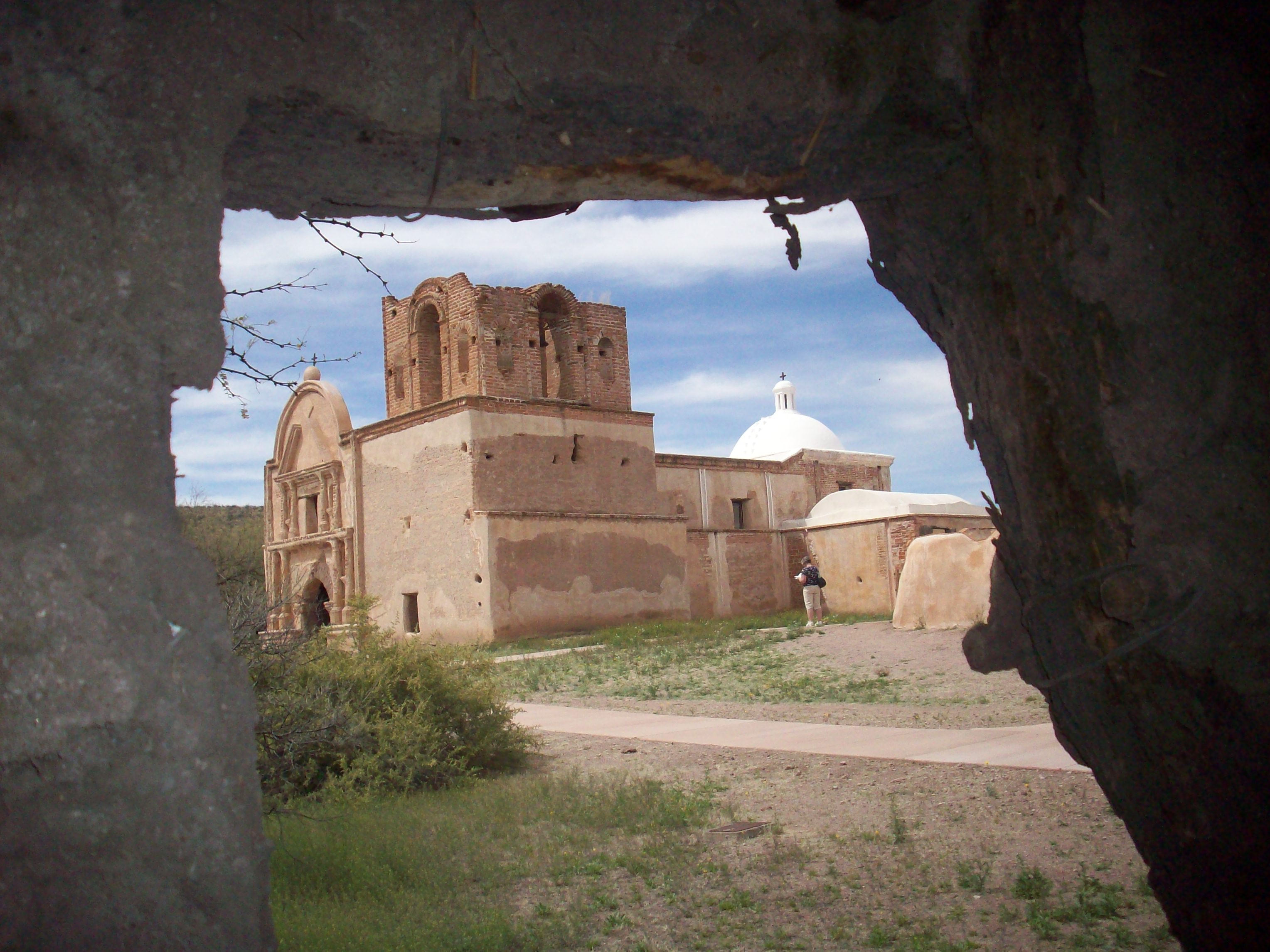
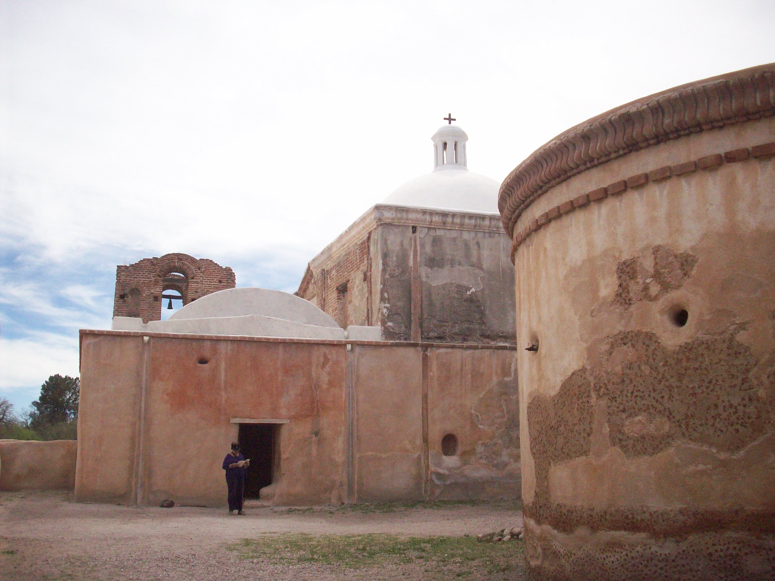
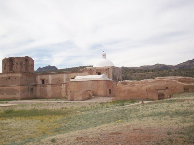
The Santa Cruz River is the only river in the United States that crosses an international border twice; it originates in the Canelo Hills of southeastern Arizona then flows south to Mexico, makes a U-turn after a few miles, and returns to Arizona near Nogales. Currently, the Santa Cruz River is dry most of the year except during the monsoon season when it is common to see surface water on the river bed. The section of the river between Tumacacori and Tubac is effluent dependent. The treated wastewater comes from the Nogales International Wastewater Treatment Plant – I mention more details about the wastewater treatment plant and Tumacacori Mission in a previous blog post published in April of 2014.

Blog 034
Tumacacori National Historical Park

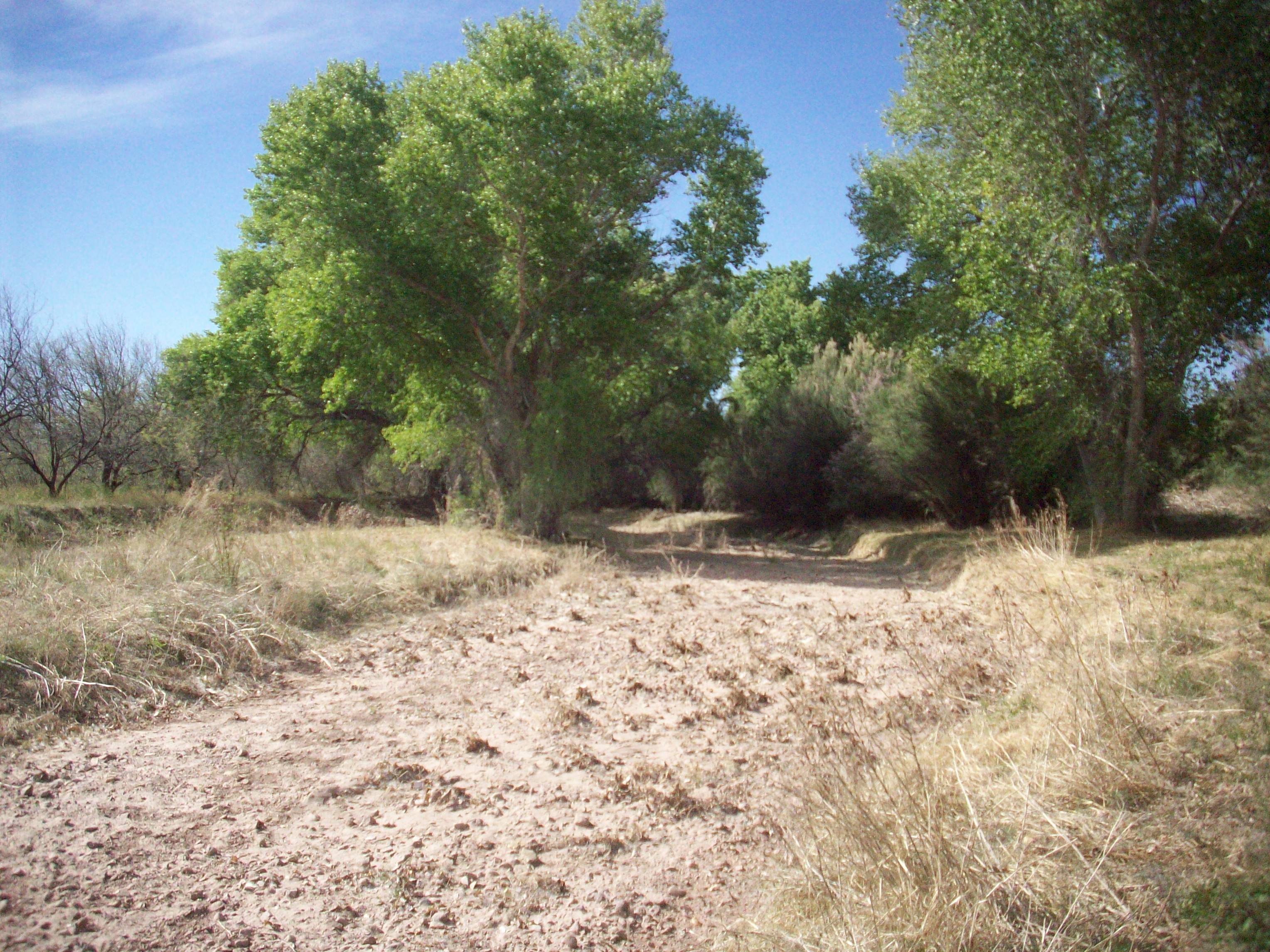
Despite the source of the surface water I find this section of the Anza Trail appealing since the cottonwood-willow gallery and the mesquite bosque provide a serene environment in which to contemplate the history of the region and enjoy the wildlife that depends on the riparian area. Riparian areas are extremely important for local and migrating wildlife species such as birds; riparian areas are also threatened ecosystems. In Arizona, it is estimated that less than 10% of the state’s original riparian habitat remains intact. According to the Arizona Riparian Council, approximately 60-75% of the state’s resident wildlife species depend on riparian areas to sustain their populations; yet, riparian areas occupy less than 0.5% of Arizona’s total land area.

The Santa Cruz River riparian area is recognized as an Important Bird and Biodiversity Area. A testament to the importance of this area for the biological diversity of the region is the recent rediscovery of the Gila topminnow. The Gila topminnow is 1-2 inch Endangered native fish. This native fish was last seen in the Upper Santa Cruz River in 2005, and after a 10 year absence the native fish species was reported during the most recent fish survey in 2015. The re-appearance of Gila topminnow in the river is possibly due to incoming flash floods from Sonoita Creek – a tributary of the Santa Cruz River where the endangered fish can still be found.

I personally did not see any fish this last time I hiked the trail, but I do remember seeing fish in the early 2000’s. The Anza trail between Tumacacori and Tubac crosses the river a couple of times, the crossing is made easier by pedestrian foot bridges provided by the Arizona Anza Trail Coalition. I hiked the trail in mid-January and possibly due to recent winter rains or maybe as a result of the last monsoon season – a portion of the trail before Clark Crossing – and possibly part of the trail located on private land all but disappeared. On that particular section of the river, a good amount of wooden debris had accumulated as well as a good amount of trash. After what felt like a leisurely walk by the river and across foot bridges the time had come to get wet and muddy feet – I enjoyed it since it provided me with an opportunity to wonder what the Anza expedition had encountered along this stretch of the river. The section of the trail from Clark Crossing to Tubac is well maintained and it’s an easy walk.

Tubac was Camp #14 of Anza’s expedition and it’s where Anza gathered all of the future settlers, made final preparations, and set out in October of 1775 as a complete expedition. Tubac had been settled by Pima Native Americans for centuries prior to the arrival of Spanish colonists. The Presidio of Tubac was founded in 1752 in response to an uprising of the local Pimas. The old presidio walls are mostly gone but portions of it as well as the presidio’s foundation can still be seen at Tubac Presidio State Historic Park – which happens to be Arizona’s 1st state park.

The town of Tubac has experienced many changes and rebirths throughout the centuries most recently as a hub for artisans and tourists in Southern Arizona; yet old Tubac where Tubac Presidio State Historic Park is located retains its small southwestern town charm. A visit to the State Historic Park and its surroundings is a visual treat since one can get a sense of the different cultural influences in the region ranging from Native American, Spanish, Mexican, and finally Anglo-European.

Tumacacori National Historical Park, the Anza Trail, the Santa Cruz River, and Tubac Presidio State Park are all easily accessible via Interstate 19 which connects Nogales, Arizona on the border with Mexico to Tucson, Arizona only about 60 miles away making it one of the shortest Interstates in the U.S and also a unique one since distances are given in meters and kilometers unlike other Interstates, so the next time you travel on I-19 or if you are ever in this area remember to look East and think about all the history and biodiversity present along this corridor.

History and Nature in and around Tumacácori

Image
Tumacacori Mission

A few years have passed since I last visited Tumacacori National Historical Park and the nearby stretch of the Santa Cruz River. I am glad I recently went back. Tumacacori, Arizona is located 18 miles north of the border town of Nogales on Interstate 19 (Exit 29). The original mission was established on the east bank of the Santa Cruz River in 1691 by Eusebio Francisco Kino, a Jesuit missionary during Spanish colonial rule, but the region and the actual settlement of Tumacacori had already been occupied for centuries by the O’odham people, also known as Pima, as well as other groups before them. Father Kino left an indelible mark in the region, so I will probably mention this historical figure in future posts. Following a revolt by Pimas, Tumacacori was relocated to the west side of the river. The construction of the church seen today began in the late 1700s.  By then, Franciscan missionaries had taken over the Jesuit missions in the region. The goal was to replace a smaller church on mission grounds, but the construction was never finalized due to inconsistent funds and lack of administrators during the early years of Mexican independence and later during the Mexican-American War. The last residents left the mission grounds in 1848, and in 1853 Tumacacori became part of the United States as a result of the Gadsden Purchase.

Image    Image

      Image    Image

 I don’t know why, but I have a weak spot for old churches. Depending on who you talk to, they can be seen as symbols of conquest, repression, power, faith, community; nonetheless, I like the peacefulness within and I like to admire the architecture.  My recent visit to Tumacacori mission included a couple of new surprises – new to me, that is – one was a small yet informative museum that tells the story of the area through different perspectives. My favorite part was listening to Pima, Yaqui, and Apache accounts in Spanish, English, and their respective languages. The other pleasant surprise was the reconstruction of the historic orchard via The Kino Heritage Fruit Trees Project which aims to locate and cultivate fruit tree cultivars that can be traced back to the late 17th and early 18th centuries. Fruit trees such as pomegranate, fig, peach, quince, and apricot. This brought back childhood memories of eating pomegranates, quince, and apricots from neighbors’ trees. I sometimes wondered why such fruit trees could be found in this region with certain frequency, I finally made the connection after seeing the orchard at Tumacacori.

Early settlements, missions – some of which blossomed into cities and/or towns – in this arid region were established along rivers. The Santa Cruz River is a binational river that starts in Southern Arizona, flows south to Mexico, and then makes a U-turn and returns to the U.S. The river is perennial only in a few sections, intermittent in many others, and effluent dependent in key sections.  Effluent from the Nogales International Wastewater Treatment Plant (NIWTP) in Rio Rico, AZ is discharged into the river and is the reason one can see surface water a few miles downstream from the plant.  The NIWTP has the capacity to treat 17.2 million gallons of sewage per day; it treats around 15 million gallons every day of which 80% comes from Mexico. The last time I walked along the river near Tumacacori, the river was flowing quite nicely; although, I do remember a peculiar smell and some trash. I also remember seeing fish. On this recent walk, there was no smell, no trash, little water, no fish – actually, it was mostly dry. The NIWTP was upgraded in 2009 which improved the quality of the effluent which benefits the wildlife dependent on the river, but apparently Mexico is sending less wastewater to the NIWTP nowadays and that coupled with drought conditions has led to the drying up of sections of the river that used to be perennial.

Image

Image

Image

Riparian areas in Arizona are few and far in between, but they are extremely important for resident wildlife as well as migrating birds. I chose this riparian area to start my blog because it has always been my favorite part of the drive between Nogales and Tucson – seeing that green ribbon of cottonwoods surrounded by the yellow-browns of the desert grasslands always brings a smile to my face. The Santa Cruz River riparian area near Tumacacori is primarily composed of cottonwoods, willows, and velvet mesquite bosques or woodlands. The riparian area attracts many species of birds and is an internationally recognized Important Bird Area which attracts many birdwatchers. The Juan Bautista de Anza National Historic Trail runs parallel to the river. The Anza Trail is easily accessible, well-maintained, and clearly marked. I walked a section of the trail between Tumacacori Mission and Clark Crossing Road (approximately 4.5 miles roundtrip). I wasn’t there at the ideal time of the day when birds are most active, but I did see/hear some activity. The Juan Bautista de Anza National Historic Trail is very interesting for its cultural, recreational, and environmental conservation contributions. The historic trail follows the 1,200 mile journey of Juan de Anza and company who in 1775 left this area to establish a settlement in San Francisco Bay. I will revisit a section of the trail near Tubac, Arizona in the near future, and I will share more information about the trail at that time. Thanks for reading my first blog post!

Image

Historia y Naturaleza en Tumacácori y sus alrededores

Han pasado algunos años desde la última vez que visité el Parque Histórico Nacional de Tumacácori y el estrecho del Río Santa Cruz aledaño al lugar; recientemente visité el lugar de nuevo y que bueno que decidí hacerlo. Tumacácori, Arizona está localizado 18 millas al norte de la cuidad fronteriza de Nogales en la carretera Interestatal 19 (Salida 29). La misión original fue establecida al este de la orilla del Río Santa Cruz en 1691por Eusebio Francisco Kino, un misionario Jesuita durante el tiempo de la colonia española, pero la región y la aldea de Tumacácori ya tenía siglos de existencia y de ocupación por pueblos como el O’odham, también conocidos como Pima, así como por otros grupos antes de ellos. El Padre Kino dejó una huella indeleble en la región, así que probablemente volveré a mencionarlo como figura histórica en futuros blogs. Después de una revuelta de los Pimas, Tumacácori fue reubicado al lado oeste del rio. La construcción de la iglesia que vemos hoy en día comenzó a finales de los años 1700s. Para ese entonces, misioneros Franciscanos ya habian tomado el control de las misiones en la región anteriormente administradas por los Jesuitas. La idea era reemplazar un pequeña capilla, pero la construcción de la iglesia nunca concluyó a causa de la inconsistencia de fondos disponibles, así como la falta de administradores durante los primeros años después de la independencia de México y después durante la Guerra Estados Unidos-México. Los últimos residentes se fueron de la misión en 1848, y en 1853 Tumacácori pasó a formar parte de los Estados Unidos como resultado de la Venta de La Mesilla.

No sé porque, pero me encantan las iglesia antigüas. Dependiendo de con quien hables, las iglesias pueden ser vistas como simbolos de conquista, represión, poder, fé, comunidad; sin embargo, me gusta el aire de tranquilidad que se respira dentro de ellas y me gusta admirar su arquitectura. Durante mi más reciente visita a Tumacácori me encontré con algunas novedades – bueno, novedades para mi – una de ellas fue encontrarme con un pequeño museo bastante informativo que relata la histora de la región através de diferentes perspectivas. Mi parte favorita fue escuchar relatos en español, inglés, y lenguas nativas Pimas, Yaquis, y Apaches. La otra novedad con la que me encontre fue la reconstrucción del huerto histórico de árboles frutales através del proyecto ‘Kino Heritage Fruit Project’ que busca localizar y cultivar variedades de árboles frutales cuyo origen se puede rastrear a finales del siglo XVII y principios del siglo XVIII.  Árboles frutales de granada, higo, membrillo, y albericoque entre otros. Esto me trajo memorias de mi niñez cuando comía granadas, membrillos, y chabacanos de los árboles de los vecinos. A veces me preguntaba porque se podian encontrar este tipo de árboles frutales en la región con regularidad, finalmente comprendí al ver la huerta en Tumacácori.

Los asentamientos y las misiones – algunas de los/as cuales se conviertieron en cuidades y pueblos – en esta región árida se asentarón a las margenes de los rios. El Río Santa Cruz es un río bi-nacional que nace en el sur de Arizona, fluye hacia México, y después hace una vuelta en U y retorna a Estados Unidos. El río fluye continuamente en pocos tramos, es intermitente en varios, y depende de efluente en algunos tramos clave. Las agua residuales tratadas por la ‘Planta Internacional de Tratamiento de Aguas Residuales de Nogales’ (NIWTP por sus siglas en inglés) en Rio Rico, Arizona descargan al río, y es por eso que se puede ver agua en la superficie algunas millas río abajo de la planta. NIWTP tiene capacidad para tratar 17.2 millones de galones de drenaje diariamente; la planta trata aproximádamente 15 millones de galones de los cuales el 80% proviene de México. La última vez que caminé a las laderas del río cerca de Tumacácori, recuerdo que el río fluía bastante bien; aunque, recuerdo un olor peculiar y haber visto basura. También recuerdo haber visto peces en el río. En esta ocasión no había olor, ni basura, ni peces – de hecho el río estaba seco la mayor parte de ese corto tramo. La NIWTP fue actualizada en el 2009 lo cual mejoró la calidad del efluente  y benefició a los animales que dependen del río; aunque aparentemente México está enviando menor cantidad de aguas residuales a la planta y eso junto con condiciones de sequía, ha llevado a que tramos del río que fluian constantemente se encuentren secos.

Las áreas ribereñas en Arizona  son contadas pero son extremedamente importantes para la fauna residente así como para las aves migratorias. Elegí esta área ribereña para iniciar mi blog porque siempre ha sido mi parte favorita del camino en carretera entre Nogales y Tucson – ver ese cordón verde de álamos rodeados por los cafés-amarillos de las praderas desérticas siempre me hace sonreir.  La área ribereña del Río Santa Cruz cerca de Tumacacori está principalmente compuesta de álamos, sauces, y bosques de mesquite. El area atrae a muchas aves y está catalogada como ‘Área Importante para las Aves’, un reconocimiento internacional que atrae a muchas personas que gustan de la observación de las aves.  El Sendero Histórico Nacional de Juan Bautista de Anza corre paralelo al río. Al Sendero de Anza se puede acceder con facilidad, le dan buen servicio de mantenimiento, y está claramente demarcado. Caminé una sección del sendero entre la Misión de Tumacácori y Clark Crossing Road (aproximádamente 4.5 millas de ida y vuelta). No caminé durante el tiempo ideal del día donde las aves se encuentran más activas, pero sí escuché y observé actividad. El Sendero de Anza es muy interesante por su significado cultural, recreacional, y de conservación de áreas naturales. El sendero histórico sigue la travesía de Juan de Anza y compañia quienes en 1775 salieron de esta área con rumbo a la Bahía de San Francisco para establecer un asentamiento. Cuando visite el sendero cerca de Tubac, Arizona en un futuro cercano,  escribiré mas información sobre este sendero. Por lo pronto – ¡Muchas gracias por leer la primera entrada de mi blog!

Sources:

Anza Trail Coalition of Arizona www.anzatrail.com

Friends of the Santa Cruz River www.friendsofsantacruzriver.org

Juan Bautista de Anza National Historic Trail www.nps.gov/juba/index.htm

Nogales International Wastewater Treatment Plant www.ibwc.gov/Organization/Operations/Field_Offices/Nogales.html

Sonoran Institute www.sonoraninstitute.org

Tumacácori National Historical Park www.nps.gov/tuma/index.htm